


G5 Trail Collective recovers from Helene and maintains accessible trail system

I was faced with a dilemma almost immediately after leaving the new temporary parking lot, which is squeezed into an acre or two of meadow between Curtis Creek and North Carolina State Route 1227. This area of the Grandfather District in Pisgah National Forest drains from the southeast slope of the Blueridge Parkway down towards the community of Old Fort, North Carolina. It was the epicenter of Hurricane Helene’s destruction of western North Carolina in the fall of 2024. The damage is still evident everywhere in the steep mountain terrain, but especially where the water collects in creeks, rivers, and any other drainage basin.
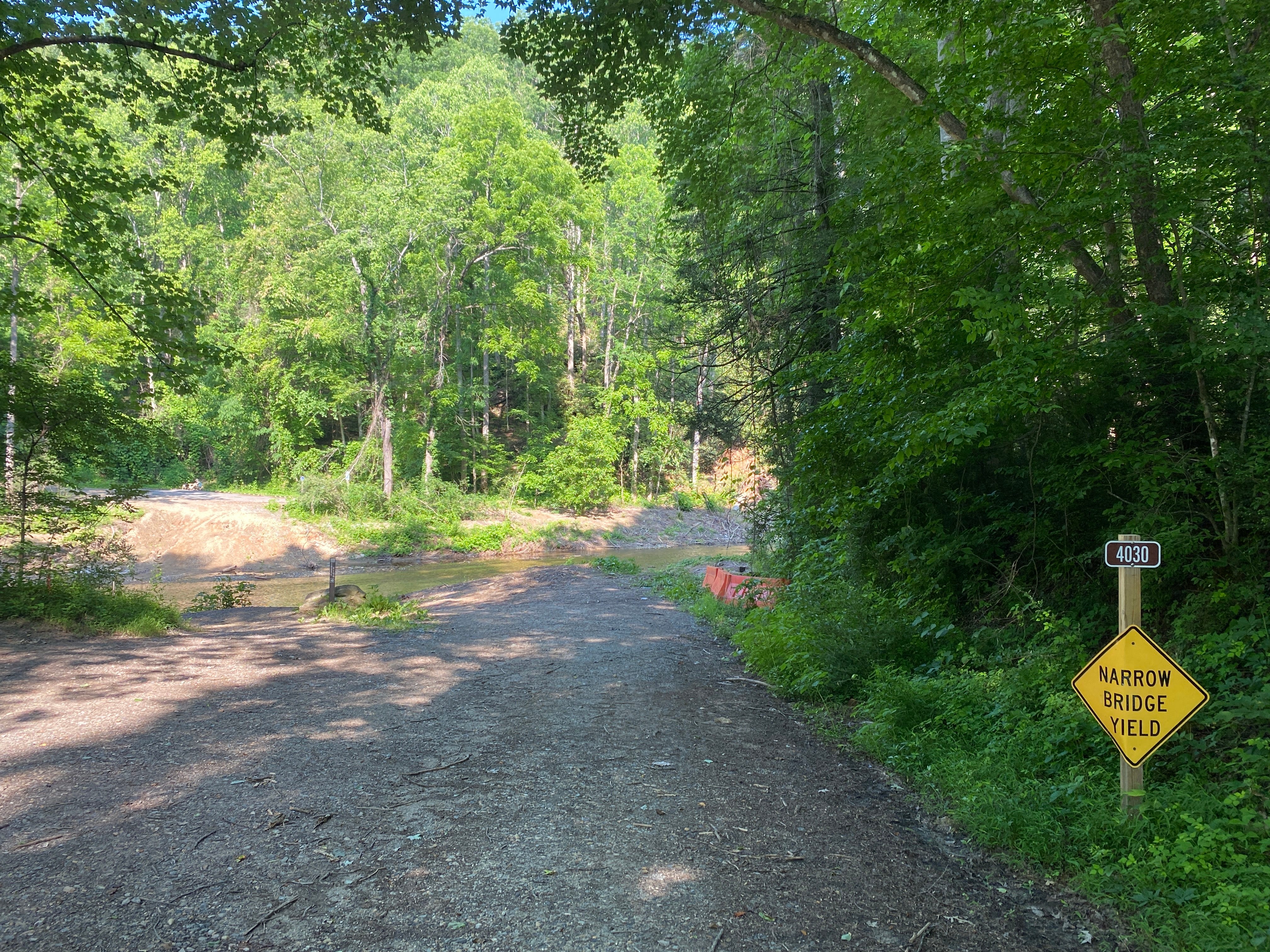
The dilemma was how to cross Curtis Creek. The ford was about 15 yards across; wide, flat, gravel-bottomed and absolutely crystal clear. The scene was perfect looking upstream, sun glinting off the rippling water and a young flyfisherman wading in shorts and sandals at the top end of the widened flat waters. Further up, a more classic mountain stream bounded down stepper grades with larger boulders and narrow, deep runs carved through the Appalachian rock and rhododendron.
Looking downstream revealed the cause of my concern and an altogether different vibe.
Tons of concrete remained wrapped around the skeletal frame of a giant steel I-beam. The bridge had been pushed from its location across the ford as though it were a few Legos kicked across the floor, still mostly sticking together in a singular piece but with some sections missing and nowhere to be seen, the I-beam sticking out like a compound fracture. Far larger, more substantial, and critical infrastructure had been wiped out across the region. But looking at the idyllic and peaceful mountain creek it was almost impossible to imagine it blasting the robust bridge off its pillars. As any fly fisherman who has fallen while wading can tell you, the force of moving water is deceptive and awe inspiring. But this was on an almost unbelievable scale.


The usual parking lot for the Old Fort Gateway Trailhead, built for 105 vehicles, is on the inaccessible side of Curtis Creek. The bridge I am pondering led to the lot and trailhead until Hurricane Helene wreaked havoc in the area. A hiker was sitting on the now misplaced bridge, taking off his shoes and socks while his dog ran across the creek.
The perfectly clear water revealed a hard gravel base but I didn’t see any reassuring tire tracks and it looked like the kind of water that was just a little deeper than it first appeared, likely causing a lot more resistance than the usual Ohio creek crossing. This would be a new experience for me. After the man and his dog waded across, I decided that I’ve both fallen in creeks and wrecked my bike enough that one more time probably wouldn’t kill me, even if those two events occur simultaneously.
Each side of the bank at the ford sloped down steeply with approximately a 10-foot drop, creating a reasonably level crossing on the former bridge from one side to the other. This drop provided the perfect accelerant to hit the water with a decent bit of speed. That momentum only carried me a few feet into the water, however, when the resistance quickly slowed me down. Soon the water reached my bottom bracket and crank. At that point, the only choice was to pedal like mad, even if it meant my feet were submerged on the bottom half of the spin cycle. A few rotations and I was up the other side feeling exhilarated and stoked, ready for the actual trails (albeit with saturated shoes). Maybe wading barefoot across was a better idea, but certainly not near as fun.
I had chosen wisely, even if my wireless shifter acted up until it dried out from being submerged.
The Old Fort Gateway Trail system, once complete, should total more than 50 miles of mountain bike trail intertwined with forest roads like Jarrett Creek Road, which heads off from the trailhead up towards the Blueridge Parkway and distant Mount Mitchell, the highest point east of the Mississippi. The system incorporates the legendary Kitsuma and Heartbreak Ridge, known for a long grueling climb to the top and an exhilarating and technical decent down to I-40 between Old Fort and Black Mountain. The G5 Trail Collective opened the first 6 miles of new trail at the Gateway trailhead in the summer of 2022, with another few miles opening the week I visited in 2025 (these new trails are not yet marked on internet maps as of this writing, but I can confirm they are riding them).

Because western North Carolina mountainbike trails tend towards the difficult end of the spectrum, it’s always been a little intimidating for a relative novice like me. The folks at G5 Trail Collective recognized this and the first phases of new trail building focused on the easiest of the planned expansion. The trails are very close to the parking lot (closer before Helene but you already know about that) and most of the climbing can be done on the relatively moderate Jarrett Creek Road, which seems to be accessible to motor vehicles only for limited trail maintenance and emergency purposes.
After climbing about a mile (and a little over 200’) up Jarrett Creek Road, singletrack trailheads start appearing and then flowing down into the surrounding woods. There are two main trails down from Jarrett Creek to the parking area, each with a separate shorter trail cut-off through it. Foundation Trail is the first and easiest, running 1.2 miles downhill with almost no perceptible climbing. Gateway Trail is the next downhill run, stretching to 1.9 miles with a little climbing and even a couple switchbacks going up towards the end. The cut-off trails, Betty’s Run and Jarrett’s Run, veer off of the main trails and shorten the length of the main downhill runs. I found these two cut-offs to be most useful when climbing up to the top on the trails rather than via Jarrett Creek Road, shortening the climbs a bit. Climbing up the trails was certainly very doable, although substantially harder than using Jarrett Creek Road, and people ride all of these trails in both directions.
Further up Jarrett Creek Road are Forager Trail (0.5 miles) and Oak Hollow Trail (0.9 miles). These trails connect to different parts of Jarrett Creek Road and are excellent in both directions, so once riders reach Forager they can take it straight to Oak Hollow, crossing Jarrett Creek where these trails meet, no longer needing the road. At the end of Oak Hollow you reach an intersection with Rostan Trail, leading off to the private Camp Grier, and also Salt Gap, a ½ mile trail shared with horses that drops down almost to the original parking area. Or one could continue out Jarrett Creek Road towards Star Gap, Mount Mitchell, Kitsuma, and potentially unlimited adventure. Taking Jarrett Creek Road to this intersection, via Oak Hollow and Forager, totals about 3.5 miles and 425 feet of climbing from the parking lot. From there one can string together upwards of 5-6 miles of trail back to the parking area with only a few hundred yards of Jarrett Creek Road between singletrack sections. Then climb up again and choose a different combination of trails, ad infinitum, or until the call of the local breweries becomes too great.
On my few trips to the Gateway Trails I have not ventured past the Oak Hollow/Rostan/Salt Gap intersection, yet I’ve thoroughly enjoyed hours going up and down the Jarrett Creek corridor. All of the trails are machine-cut, packed smooth and very fast. They are wide at the base of the system and get more narrow as you go uphill. They do not offer a ton of technical challenge, but they flow and twist like a rollercoaster on methamphetamine. Speed becomes the element of play, and like fire for a pyromaniac it is irresistible but constantly on the edge of burning you. The slope of the mountain and near perfect surface allow gravity to pull you very quickly to speeds that test your cornering skills and resolve.
But the real story of this trip is the brilliance and persistence of the G5 Trail Collective. Western North Carolina is a mountain biking paradise but one that was not always welcoming for less experienced riders. The Gateway Trailhead System is truly that: a geographic gateway to the area from the east but also a gateway for less confident riders to enter the wonderful world of WNC trails. Starting with an accessible location and non-threatening trails was perfect, and now as the more challenging trails are created the whole system becomes a playground of varied options and routes. The brand new Catawba View Trail–at 1.5 miles, still easy but with more ups-and-downs and tighter corners than some of the other trails–is incrementally both more difficult and more fun than some of the first trails opened. As this difficulty gradually increases through the (eventually) 50-mile system, a rider can also progress skills and confidence up to the Kitsuma level and beyond.
Although it is recovering, the region continues to suffer from Hurricane Helene. Numerous major roads remain closed from landslides or destroyed bridges. Just in Old Fort alone, a few miles from the trailhead, there are 3 main roads into town, each crossing a river or creek. One remains closed and a second is accessible only through a temporary metal bridge staked up next to the original road.
Yet the G5 Trail Collective, working with the forest service, found a way to clear the trails and even create a temporary parking area so mountainbikers, hikers and equestrians can access these trails. It’s this kind of hard work and dedication by trail angels around the country that allows us all to enjoy our twisted outdoor recreation. If you have an opportunity to visit these trails, consider donating to the non-profit G5 Trail Collective and definitely spend some money in one of the local towns. In addition to biking, the area is known for its breweries so it’s easy to find a fun way to help the local economy recover from the devastation of Helene.
The world is a crazy and wild place, and we never know what storm might blow our way, but if we all keep up our own corner of the world half as well as the G5 folks care for the Old Fort area, it will remain a beautiful and exciting world as well.
 | A guest post by
|